
We lined up for the ferry at the assigned time - too early, as it turned out! But before that we managed to race to a garage which treats rust - hooray! They seem to know what they are doing and have a hoist that will lift the camper. We'll go back there on our return trip and get that important job done. In the meantime, the ferry. Delayed four hours because of heavy winds so instead of leaving at 11:30, it left at 4:30 but with wi-fi in the terminal, we kept busy. Not many cars - mostly huge trucks carrying food or whatever is needed to feed people who live on the rock!
 |
Ferry nest to ours, of similar design

En route, trucks chained down to hold in place. Last time we saw this was in New Zealand crossing from North Island over an equally rough sea.

Trucks on lower deck - very windy!!!

From the ferry dock at Port Aux Basques, we set off north and it was not long before we were winding along the coast with wilderness on all sides.
 |
Here, the road winds down into Cornerbrook. Took a quick look around town.

Headed for Gros Morne park and stopped at a beautiful campsite in Lomond. The showers seemed to be outdoor ones - at least this was the case at the washrooms next to the beach where we parked. Richard was more anxious than I for a shower so he braved the cool water and the chill winds - I had to take the photos!

Sunset at this lovely spot was an additional treat. No other campers around, except for two tents in another area. We had the place to ourselves. En route, we had passed another private campsite that mostly resembled a parking lot for rvs. A few miles down the road was the park site - what a choice!

We like to cook and eat outside but sometimes it is too cold or too windy or too dark!

Ready for dinner in the camper!
 |
| Gloriously sunny morning - perfect for a hike |
We set off from Lomond for the Visitor Center and a guided 5km walk on the Tablelands.
Extremely well organized - the Centre was excellent - so much helpful information. We joined others a few kilometres down the road from the Centre and followed Angie Payne along the trail. Without her, we would have seen nothing really.
The Tablelands, as the next photo shows are brown hills on the left side of a long
valley - the hills are flat-topped & brown with very little vegetation. Th right side is treed. Apparently, the Tablelands appeared when the upper plate of two shifting tectonic plates picked up magma from under the earth's crust and deposited it in this spot. Later the plates moved separated to form the Atlantic ocean. The magma was left behind and since it contains iron, nickel and other minerals which are toxic to plants, the hills are mostly bare. What grows there has taken root in blown soil from other areas.
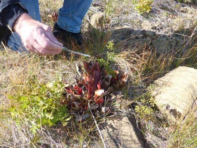
Angie carried little syringes for all of us to use to draw water from the petals of the pitcher plant and observe the larvae and dead insects that drowned there. The plant, growing in harsh conditions in soil with few nutrients, uses the decomposed bodies of insects for its food. Marvellous.

We spent a couple of hours in the afternoon on a steep climb up to a lookout above the Centre.


An alternate route for the descent from the lookout went down into the bogs that we saw everywhere in the north. The trail here was gravelled, but in many cases, the trail is a board walk, elevated above the bog, partly to protect the plants from being trampled on but also partly to make it possible for people to cross what are very wet wetlands. Richard stuck his foot into what looked pretty firm ground and nearly sank his whole shoe into the spongy black soil!
No comments:
Post a Comment